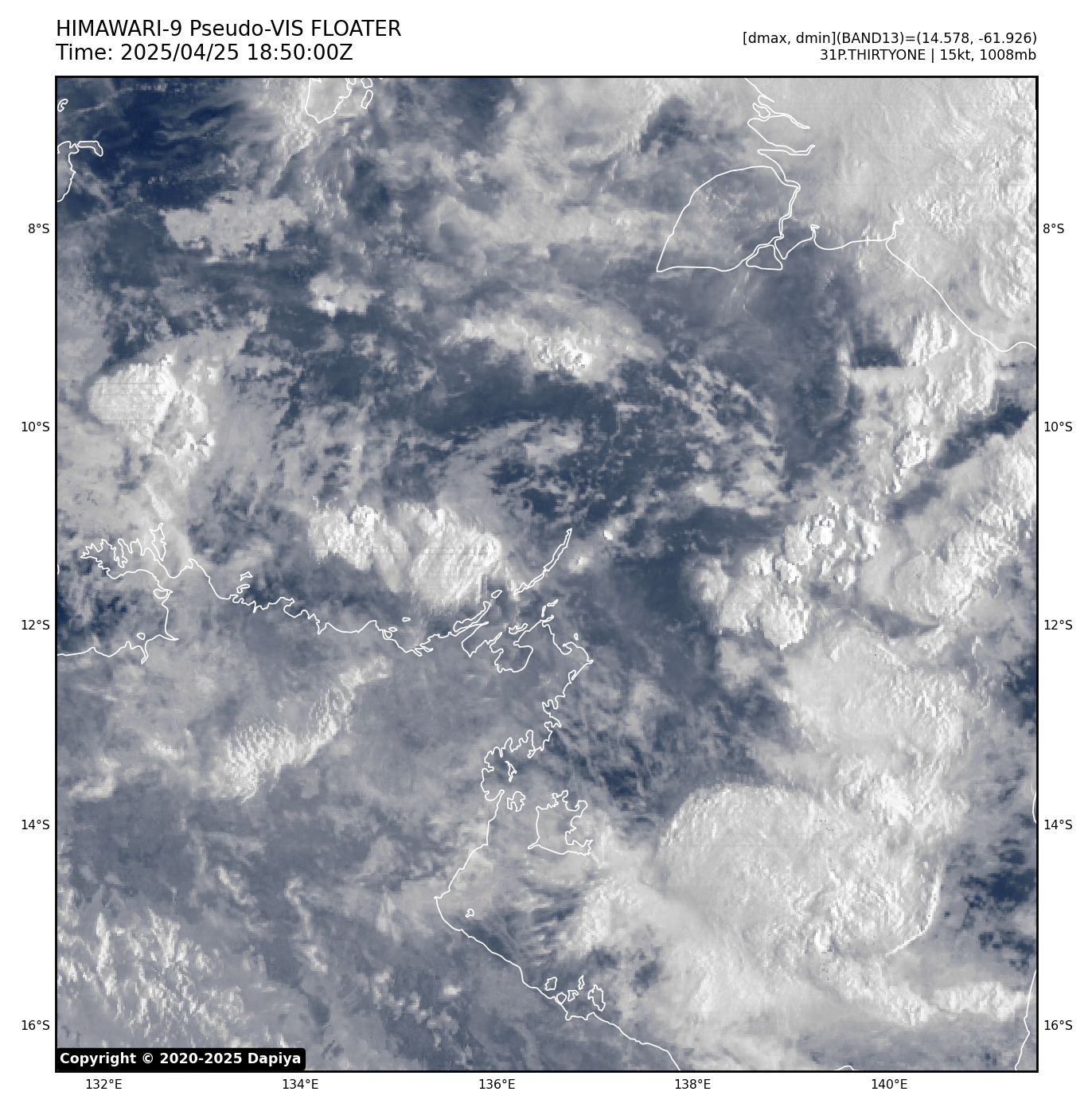
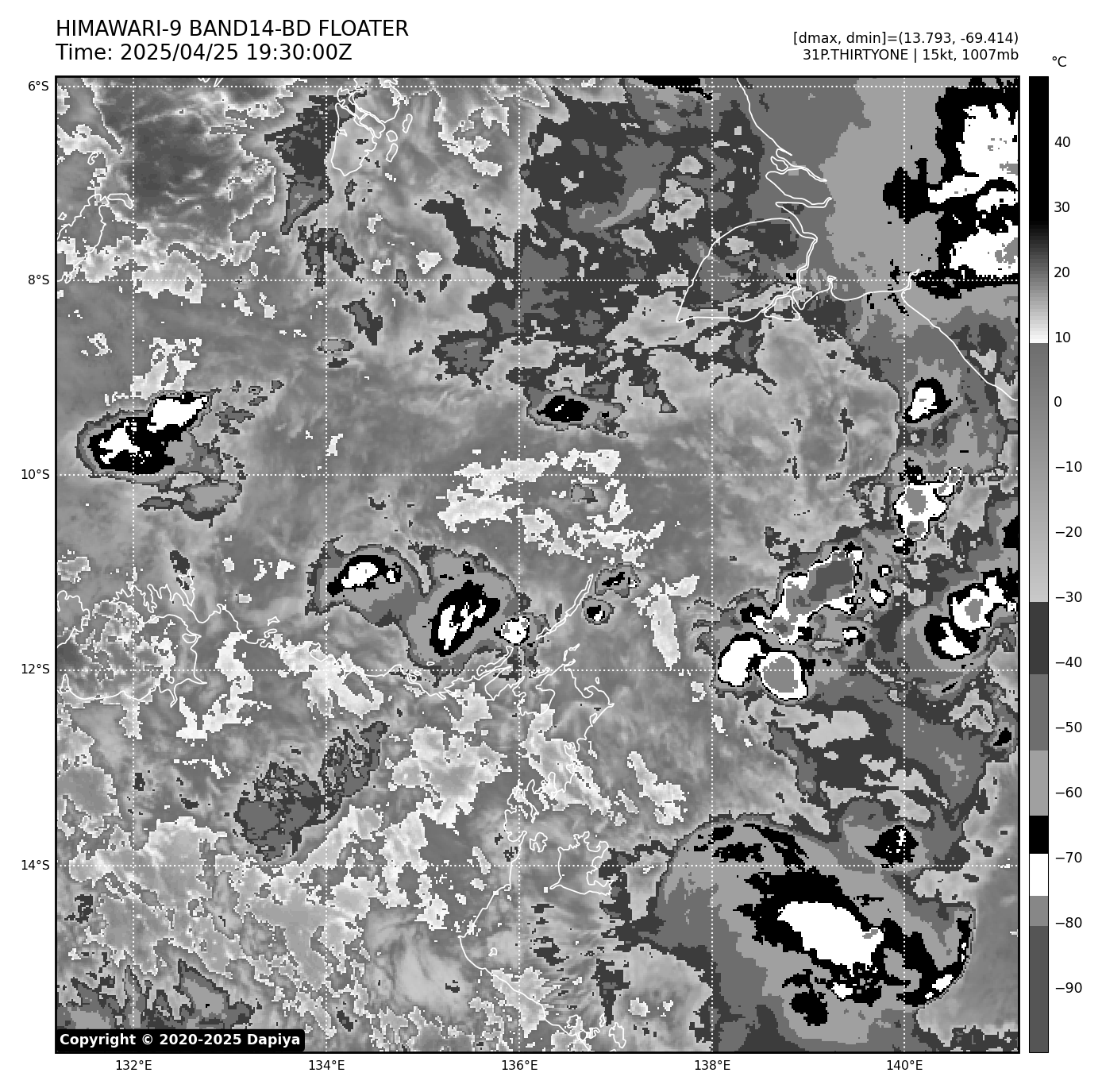
找回密码
 立即注册
搜索
查看: 1694|回复: 62

阿拉弗拉海热带低压30U(31P)

[复制链接]

25

主题

53

回帖

1085

积分

论坛版主-副热带高压

积分
1085
QQ
发表于 2025-4-13 14:44 | 显示全部楼层 |阅读模式
本帖最后由 yhh 于 2025-4-25 12:25 编辑

实时云图


编扰资讯

97P INVEST 250413 0600 11.5S 136.7E SHEM 15 0

本帖子中包含更多资源

您需要 登录 才可以下载或查看,没有账号?立即注册

×

评分

参与人数 1金钱 +3 威望 +3 收起 理由
2018_26W + 3 + 3

查看全部评分

16

主题

1524

回帖

2620

积分

台风

超顶超165kt

积分
2620
发表于 2025-4-13 17:56 | 显示全部楼层
一团黑,不太好
GFS数值

本帖子中包含更多资源

您需要 登录 才可以下载或查看,没有账号?立即注册

×
我深爱着的——风云

27

主题

3526

回帖

7037

积分

强台风

Super Typhoon

积分
7037
发表于 2025-4-13 20:50 | 显示全部楼层
Tropical Low 30U
A tropical low (30U) may develop in the eastern Arafura Sea or Gulf of Carpentaria.
  • A tropical low 30U may form early in the week in the eastern Arafura Sea.
  • If it stays over water it may develop, either in the eastern Arafura Sea or Gulf of Carpentaria.
  • It has a Low chance of developing into a tropical cyclone from Wednesday.
  • Whilst there is large uncertainty in where and when 30U may form and move, communities in the area should keep up-to-date with the latest forecasts.
Last updated
4 hours ago, 08:42 am UTC

Tropical lowsTomorrow 10:00 am Tomorrow 10:00 pm Tue 15  Apr 10:00 am Tue 15  Apr 10:00 pm Wed 16  Apr 10:00 am Wed 16  Apr 10:00 pm Thu 17  Apr 10:00 am Thu 17  Apr 10:00 pm Fri 18  Apr 10:00 am Fri 18  Apr 10:00 pm Sat 19  Apr 10:00 am Sat 19  Apr 10:00 pm Sun 20  Apr 10:00 am Sun 20  Apr 10:00 pm
Tropical Low 30U null (None) 1 (Very Low) 1 (Very Low) 1 (Very Low) 10 (Low) 15 (Low) 15 (Low) 15 (Low) 15 (Low) 15 (Low) 15 (Low) 10 (Low) 5 (Low) 5 (Low)

本帖子中包含更多资源

您需要 登录 才可以下载或查看,没有账号?立即注册

×
P

28

主题

3797

回帖

5306

积分

强台风

上海地区气象爱好者

积分
5306
发表于 2025-4-14 21:49 | 显示全部楼层
都到30了,还是很多产的
破阵子·五月二十日望洋兴叹
学前聊观数值,全球各洋多旋。去年今日玛娃生,巅峰顶超撼风迷。曾想八六八。
而今极阔西太,惟有云团孱弱。风切遍洋皆死路,黑潮暖水何朝用?静待主风季。

27

主题

3526

回帖

7037

积分

强台风

Super Typhoon

积分
7037
发表于 2025-4-15 10:10 | 显示全部楼层
Tropical Low 30U
A tropical low (30U) may develop in the eastern Arafura Sea or Gulf of Carpentaria during the week.
  • A tropical low 30U may form in the eastern Arafura Sea on Tuesday or Wednesday.
  • Later in the week the system may move to the east or southeast.
  • If it stays over water it may develop, either in the eastern Arafura Sea or Gulf of Carpentaria and has a Low chance of developing into a tropical cyclone from Wednesday through to Sunday.
  • Whilst there is large uncertainty in where and when 30U may form and move, communities in the area should keep up-to-date with the latest forecasts.
Last updated
an hour ago, 12:29 am UTC

Tropical lowsToday 12:00 pm Tomorrow 12:00 am Tomorrow 12:00 pm Thu 17  Apr 12:00 am Thu 17  Apr 12:00 pm Fri 18  Apr 12:00 am Fri 18  Apr 12:00 pm Sat 19  Apr 12:00 am Sat 19  Apr 12:00 pm Sun 20  Apr 12:00 am Sun 20  Apr 12:00 pm Mon 21  Apr 12:00 am Mon 21  Apr 12:00 pm Tue 22  Apr 12:00 am
Tropical Low 30U 1 (Very Low) 5 (Low) 10 (Low) 15 (Low) 15 (Low) 15 (Low) 15 (Low) 15 (Low) 15 (Low) 10 (Low) 5 (Low) 1 (Very Low) 1 (Very Low) null (None)

本帖子中包含更多资源

您需要 登录 才可以下载或查看,没有账号?立即注册

×
P

27

主题

3526

回帖

7037

积分

强台风

Super Typhoon

积分
7037
发表于 2025-4-16 08:35 | 显示全部楼层

JTWC:LOW


ABPW10 PGTW 160000
MSGID/GENADMIN/JOINT TYPHOON WRNCEN PEARL HARBOR HI//
SUBJ/SIGNIFICANT TROPICAL WEATHER ADVISORY FOR THE WESTERN AND SOUTH
PACIFIC OCEANS REISSUED/160000Z-160600ZAPR2025//
RMKS/
1. WESTERN NORTH PACIFIC AREA (180 TO MALAY PENINSULA):
   A. TROPICAL CYCLONE SUMMARY: NONE.
   B. TROPICAL DISTURBANCE SUMMARY: NONE.
   C. SUBTROPICAL SYSTEM SUMMARY: NONE.
2. SOUTH PACIFIC AREA (WEST COAST OF SOUTH AMERICA TO 135 EAST):
   A. TROPICAL CYCLONE SUMMARY: NONE.
   B. TROPICAL DISTURBANCE SUMMARY:
      (1) AN AREA OF CONVECTION (INVEST 97P) HAS PERSISTED NEAR 9.1S
135.4E, APPROXIMATELY 337 NM NORTHEAST OF DARWIN, AUSTRALIA. ANIMATED
MULTISPECTRAL SATELLITE (MSI) IMAGERY AND A 152052Z SSMIS F17 91H
MICROWAVE IMAGE DEPICT A SLOWLY CONSOLIDATING, PARTIALLY EXPOSED LOW
LEVEL CIRCULATION CENTER (LLCC) WITH FORMATIVE CONVECTIVE BANDING
ALONG THE SOUTHERN PERIPHERY OF THE LLCC. A RECENT OBSERVATION FROM
CAPE WESSEL, AUSTRALIA INDICATES SUSTAINED EASTERLY WINDS OF 19
KNOTS. ENVIRONMENTAL ANALYSIS REVEALS A MARGINALLY FAVORABLE
ENVIRONMENT FOR DEVELOPMENT WITH LOW VERTICAL WIND SHEAR (VWS) OF 10-
15 KNOTS, WEAK UPPER-LEVEL OUTFLOW AND WARM SEA SURFACE TEMPERATURES
(SST) OF 29-30 C. DETERMINISTIC AND ENSEMBLE MODELS ARE IN AGREEMENT,
PORTRAYING SLOW DEVELOPMENT OVER THE NEXT 24 TO 48 HOURS. MAXIMUM
SUSTAINED SURFACE WINDS ARE ESTIMATED AT 20 TO 25 KNOTS. MINIMUM SEA
LEVEL PRESSURE IS ESTIMATED TO BE NEAR 1004 MB. THE POTENTIAL FOR THE
DEVELOPMENT OF A SIGNIFICANT TROPICAL CYCLONE WITHIN THE NEXT 24
HOURS IS LOW.
      (2) NO OTHER SUSPECT AREAS.
   C. SUBTROPICAL SYSTEM SUMMARY:
...
      (2) NO OTHER SUBTROPICAL SYSTEMS.
3. JUSTIFICATION FOR REISSUE: REMOVED FINAL WARNING INFORMATION FOR
30P. ADDED 30P AS A SUBTROPICAL SYSTEM AND ADDED A LOW AREA IN
PARAGRAPH 2.B.(1).//
NNNN

本帖子中包含更多资源

您需要 登录 才可以下载或查看,没有账号?立即注册

×
P

27

主题

3526

回帖

7037

积分

强台风

Super Typhoon

积分
7037
发表于 2025-4-16 10:10 | 显示全部楼层
Tropical Low 30U
A weak tropical low (30U) lies in the northeastern Arafura Sea.
  • From Thursday or Friday the tropical low, 30U, may move to the east or southeast.
  • If it stays over water it may develop, either in the eastern Arafura Sea or Gulf of Carpentaria, and it has a Low chance of developing into a tropical cyclone from Thursday through to Monday.
  • There is considerable uncertainty in both the track and development, so communities in the region should stay up to date with the latest forecasts.
Last updated
2 hours ago, 11:42 pm UTC

Tropical lowsToday 12:00 pm Tomorrow 12:00 am Tomorrow 12:00 pm Fri 18  Apr 12:00 am Fri 18  Apr 12:00 pm Sat 19  Apr 12:00 am Sat 19  Apr 12:00 pm Sun 20  Apr 12:00 am Sun 20  Apr 12:00 pm Mon 21  Apr 12:00 am Mon 21  Apr 12:00 pm Tue 22  Apr 12:00 am Tue 22  Apr 12:00 pm Wed 23  Apr 12:00 am
Tropical Low 30U 1 (Very Low) 1 (Very Low) 10 (Low) 10 (Low) 15 (Low) 15 (Low) 15 (Low) 10 (Low) 10 (Low) 5 (Low) 1 (Very Low) 1 (Very Low) null (None) null (None)

本帖子中包含更多资源

您需要 登录 才可以下载或查看,没有账号?立即注册

×
P

27

主题

3526

回帖

7037

积分

强台风

Super Typhoon

积分
7037
发表于 2025-4-17 09:50 | 显示全部楼层
Tropical Low 30U
A tropical low (30U) lies in the northeastern Arafura Sea.
  • Tropical low, 30U, is forecast to move to the east southeast towards the Gulf of Carpentaria from today and over the weekend.
  • If it stays over water it may develop in the eastern Arafura Sea or Gulf of Carpentaria, with a Low chance of developing into a tropical cyclone from Friday night through to Monday.
  • There is considerable uncertainty in both the track and development of 30U, so communities in the region should stay up to date with the latest forecasts.
Last updated
an hour ago, 12:48 am UTC

Tropical lowsToday 12:00 pm Tomorrow 12:00 am Tomorrow 12:00 pm Sat 19  Apr 12:00 am Sat 19  Apr 12:00 pm Sun 20  Apr 12:00 am Sun 20  Apr 12:00 pm Mon 21  Apr 12:00 am Mon 21  Apr 12:00 pm Tue 22  Apr 12:00 am Tue 22  Apr 12:00 pm Wed 23  Apr 12:00 am Wed 23  Apr 12:00 pm Thu 24  Apr 12:00 am
Tropical Low 30U 1 (Very Low) 1 (Very Low) 15 (Low) 15 (Low) 15 (Low) 15 (Low) 15 (Low) 10 (Low) 5 (Low) 1 (Very Low) 1 (Very Low) null (None) null (None) null (None)

本帖子中包含更多资源

您需要 登录 才可以下载或查看,没有账号?立即注册

×
P

27

主题

3526

回帖

7037

积分

强台风

Super Typhoon

积分
7037
发表于 2025-4-17 14:00 | 显示全部楼层

JTWC:REMAINS LOW


ABPW10 PGTW 170600
MSGID/GENADMIN/JOINT TYPHOON WRNCEN PEARL HARBOR HI//
SUBJ/SIGNIFICANT TROPICAL WEATHER ADVISORY FOR THE WESTERN AND SOUTH
PACIFIC OCEANS/170600Z-180600ZAPR2025//
RMKS/
1. WESTERN NORTH PACIFIC AREA (180 TO MALAY PENINSULA):
   A. TROPICAL CYCLONE SUMMARY: NONE.
   B. TROPICAL DISTURBANCE SUMMARY: NONE.
   C. SUBTROPICAL SYSTEM SUMMARY: NONE.
2. SOUTH PACIFIC AREA (WEST COAST OF SOUTH AMERICA TO 135 EAST):
   A. TROPICAL CYCLONE SUMMARY: NONE.
   B. TROPICAL DISTURBANCE SUMMARY:
      (1) THE AREA OF CONVECTION (INVEST 97P) PREVIOUSLY LOCATED NEAR
9.0S 136.8E IS NOW LOCATED NEAR 8.9S 136.7E, APPROXIMATELY 204 NM NORTH
OF GOVE AIRPORT, AUSTRALIA. ANIMATED MULTISPECTRAL SATELLITE IMAGERY
REVEALS A PARTIALLY OBSCURED, CONSOLIDATING LOW LEVEL CIRCULATION
EMBEDDED UNDER A LARGER AREA OF FLARING CONVECTION. A 170014Z ASCAT
METOP-B IMAGE REVEALS A SMALL AREA OF 25 KTS COMING FROM THE NORTH
WITHIN THE EASTERN SEMICIRCLE AND 15-20 KTS ELSEWHERE. ENVIRONMENTAL
ANALYSIS REVEALS A MARGINALLY FAVORABLE ENVIRONMENT FOR DEVELOPMENT WITH
LOW (10-15 KNOTS) VERTICAL WIND SHEAR, WEAK UPPER-LEVEL OUTFLOW, AND
WARM (29-30C) SEA SURFACE TEMPERATURES. DETERMINISTIC AND ENSEMBLE
MODELS ARE IN GOOD AGREEMENT, SHOWING INTENSIFICATION IN THE GULF OF
CARPENTARIA OVER THE NEXT 24-48 HOURS. MAXIMUM SUSTAINED SURFACE WINDS
ARE ESTIMATED AT 23 TO 28 KNOTS. MINIMUM SEA LEVEL PRESSURE IS ESTIMATED
TO BE NEAR 1006 MB. THE POTENTIAL FOR THE DEVELOPMENT OF A SIGNIFICANT
TROPICAL CYCLONE WITHIN THE NEXT 24 HOURS REMAINS LOW.
      (2) NO OTHER SUSPECT AREAS.
   C. SUBTROPICAL SYSTEM SUMMARY: NONE.//
NNNN

本帖子中包含更多资源

您需要 登录 才可以下载或查看,没有账号?立即注册

×

点评

图中哪里有52kt?  发表于 2025-4-17 14:45
P

27

主题

3526

回帖

7037

积分

强台风

Super Typhoon

积分
7037
发表于 2025-4-17 15:00 | 显示全部楼层
本帖最后由 pocketbox 于 2025-4-17 15:30 编辑

IDD20020
TROPICAL CYCLONE TECHNICAL BULLETIN: AUSTRALIA - NORTHERN REGION
Issued by AUSTRALIAN BUREAU OF METEOROLOGY TROPICAL CYCLONE WARNING CENTRE
at: 0708 UTC 17/04/2025
Name: Tropical Low  
Identifier: 30U
Data At: 0600 UTC
Latitude: 9.2S
Longitude: 136.9E
Location Accuracy: within 35nm (65 km)
Movement Towards: southeast (139 deg)
Speed of Movement: 5 knots (10 km/h)
Maximum 10-Minute Wind: 30 knots (55 km/h)
Maximum 3-Second Wind Gust: 45 knots (85 km/h)
Central Pressure: 1002 hPa
Radius of 34-knot winds NE quadrant:
Radius of 34-knot winds SE quadrant:
Radius of 34-knot winds SW quadrant:
Radius of 34-knot winds NW quadrant:
Radius of 48-knot winds NE quadrant:
Radius of 48-knot winds SE quadrant:
Radius of 48-knot winds SW quadrant:
Radius of 48-knot winds NW quadrant:
Radius of 64-knot winds:   nm (  km)
Radius of Maximum Winds:   nm (  km)
Dvorak Intensity Code: T2.0/2.0/D1.0/24HRS STT:D0.5/06HRS
Pressure of outermost isobar: 1007 hPa
Radius of outermost closed isobar: 150 nm (280 km)
FORECAST DATA
Date/Time    : Location    : Loc. Accuracy: Max Wind   : Central Pressure
(UTC)        : degrees     :      nm  (km): knots(km/h): hPa
+06:  17/1200:  9.4S 137.7E:     045 (085):  030  (055): 1002
+12:  17/1800: 10.0S 138.6E:     055 (100):  030  (055): 1002
+18:  18/0000: 10.6S 139.1E:     065 (115):  030  (055): 1002
+24:  18/0600: 11.1S 139.8E:     070 (125):  030  (055): 1002
+36:  18/1800: 11.9S 140.4E:     080 (150):  035  (065):  999
+48:  19/0600: 12.5S 140.7E:     100 (180):  035  (065):  998
+60:  19/1800: 12.8S 140.7E:     120 (225):  040  (075):  995
+72:  20/0600: 12.9S 140.1E:     140 (255):  035  (065):  998
+96:  21/0600: 12.7S 137.6E:     175 (325):  030  (055): 1002
+120: 22/0600: 11.7S 134.2E:     200 (370):  025  (045): 1005
REMARKS:
Tropical Low 30U lies over the northeast Arafura Sea and has been moving
generally southeast. There is fair confidence in the centre position which has
been based on recent scatterometry (ASCAT-B at 0012 UTC), and animated visible
satellite imagery.

Dvorak analysis is based on curved band pattern (0.3-0.4 wrap), averaged over 3
hours, giving a DT of 2.0. MET is 2.0 with a D trend and no adjustment to PAT.
FT/CI of 2.0 based on DT. Intensity is set at 30 kn based on ASCAT-B at 0012
UTC.

30U currently lies under moderate northeasterly vertical wind shear, under the
western edge of an upper anticyclone. As 30U tracks to the southeast, it may
move under the axis of the anticyclone and shear may ease. Deep tropical
moisture and high sea surface temperatures (30-31C) are otherwise in place in
the short to medium term. Good upper outflow, particularly to the north, is
also present, and may improve tomorrow and during the weekend. Only slow
development is forecast in the next 24 to 48 hours, though there is some
potential for it to be located in a more favourable environment, potentially
developing more than forecast. Additionally, as a small system, it could
respond rapidly to any improvement in its environment, and it has some
potential to reach tropical cyclone intensity quickly.

Low-level westerly flow is currently steering 30U to the southeast. This flow
is expected to somewhat increase tomorrow, with slightly faster motion to the
southeast. Into the weekend a deeper circulation may continue to be steered to
the south southeast with the influence of a mid-level anticyclone to the
southeast. From late weekend or early next week, a high pressure ridge is
expected to strengthen over central Australia, steering 30U to the west or
northwest, towards the eastern Top End. Though there is high uncertainty in the
track at this lead time.

Copyright Commonwealth of Australia
==
The next bulletin for this system will be issued by: 17/1330 UTC.


Time (ACST)Intensity CategoryLatitude
(decimal deg.)
Longitude
(decimal deg.)
Estimated Position
Accuracy (km)
0hr4 pm April 17tropical low9.2S136.9E65
+6hr10 pm April 17tropical low9.4S137.7E85
+12hr4 am April 18tropical low10.0S138.6E100
+18hr10 am April 18tropical low10.6S139.1E115
+24hr4 pm April 18tropical low11.1S139.8E125
+36hr4 am April 19tropical low11.9S140.4E150
+48hr4 pm April 19tropical low12.5S140.7E180
+60hr4 am April 20tropical low12.8S140.7E225
+72hr4 pm April 20tropical low12.9S140.1E255


Time (AEST)Intensity CategoryLatitude
(decimal deg.)
Longitude
(decimal deg.)
Estimated Position
Accuracy (km)
0hr4 pm April 17tropical low9.2S136.9E65
+6hr10 pm April 17tropical low9.4S137.7E85
+12hr4 am April 18tropical low10.0S138.6E100
+18hr10 am April 18tropical low10.6S139.1E115
+24hr4 pm April 18tropical low11.1S139.8E125
+36hr4 am April 19tropical low11.9S140.4E150
+48hr4 pm April 19tropical low12.5S140.7E180
+60hr4 am April 20tropical low12.8S140.7E225
+72hr4 pm April 20tropical low12.9S140.1E255

本帖子中包含更多资源

您需要 登录 才可以下载或查看,没有账号?立即注册

×
P
您需要登录后才可以回帖 登录 | 立即注册

本版积分规则

QQ|Archiver|手机版|小黑屋|TY_Board论坛

GMT+8, 2025-4-25 23:03 , Processed in 0.043264 second(s), 22 queries .

Powered by Discuz! X3.5

© 2001-2024 Discuz! Team.

快速回复 返回顶部 返回列表